Search This Blog

Saturday, February 28, 2009

Back Home Again.....The Final Entry

To carry on from the last entry.....We left the Pass Creek campsite at 7:30 Thursday morning,just after the rain stopped.Travelling north through Eugene,there was fresh snow on the ground at elevations below 500 ft.There were a few left over rain squalls,but a nice day for driving.Portland was a nice quiet drive through the centre as was Seattle, surprisingly.We hit just the right times through both cities,Portland just after the morning rush,and Seattle just before the afternoon rush.

Getting used to the big drop in temperature was the big thing as it was in the 30's at Marysville Wash,when we stopped at the Tulalip Casino's r.v. parking area.There were very few returning snowbirds,maybe 8.Usually there is a big crowd.
Yesterday morning dawned a nice crisp sunny day near freezing as I said goodbye to Ron & Sue and set out alone for the final 2 1/2 hours to home,stopping at the nearby wal-mart for a final few food items you cant get at home.(found some more chicken fried steak)
It was around 10:30 am when I arrived at the Sumas border crossing.It was very quiet,only 2 cars in front of me.Maybe that's not a good thing because they pulled me in for an inspection(first time ever.)They went through the van and trailer with a fine toothed comb,finding a receipt for the new tires that I was forced to buy back in early Nov.(BUSTED!)They seized everything and made me sweat for over an hour in the waiting area.Crazy thoughts were going through my head....Are the mounties going to come through the door any minute,and cuff me? They asked me before the receipt was revealed."Are you sure you have nothing else to declare?)I didn't want to backtrack at that stage for fear of getting into trouble,but that was a mistake as they showed me the receipt for $1800.U/S, and they were giving this dummy a last chance to come clean.
Finally they gave me the benefit of the doubt because I told them if I was trying to hide something,I wouldn't have left the receipt where they could find it.And that I just forgot,because I'm and old fart.
It makes me wonder,are times a changing?Or is it because I'm travelling alone now.I've never had any problems crossing both ways before when the wife was with me.So now I'm $308. poorer in duties, with a lesson learned,and some very expensive tires on both van and trailer,because the same tires at home would have cost half of what i totally paid.
Arriving home very humbled and in a mild state of shock,all was well with the little park model I call home,and I quickly got the water and furnace turned on and proceeded to unload....Now its back to my Archie Bunker chair and big screen t.v.

I enjoyed the 2 months of doing this blog,it became almost an obsession,seeing if i could make entry's daily...I think i missed only 2 days.Please...to you readers,keep this in your favourites and occasionally check for my next wandering adventure.

MY LOCATION

Thursday, February 26, 2009

Pass Creek County Park....Curtin Oregon..Day 3

Well...another travel day is under our belt.Yesterday we left Rolling Hills Casino just after 7:30 a.m. in an overcast with temps in the high 40's,topping 50 shortly after.It was dry over the hump,(Siskiyous.)Below is the rest area near Hornbrook Ca.,just before entering Oregon and Siskiyou pass.Taken around 10:30 am and 50 degrees at this higher altitude. We even had some sunny breaks as we repaired some wiring on the connection to Ron & Sue's" towed", after a little mishap in the gas station at Redding.


It was dry and mild all the way to Grants Pass Oregon.....Then the rains came..and came.It was only 1:30 when we reached Seven Feathers Casino truck stop for fuel....So we decided to put in some more road time.We put in another 65 miles and found this delightfull little"waterlogged" campground,just off the I-5 near Curtin.
But as you can see in the next picture,just a little swamped.You wonder why we picked water filled sites,instead of dry one's?Well,these were the only ones with a clear enough shot for the 2 satellite dishes.
This park would be a real jewel in drier times,as its nicely landscaped with a small lake full of Canada Geese and a few muscovy's.The only down side is much of what the geese leave behind is all over the campsite.

This park is full hookup,$20. And we needed to have a little power for a change,just to hunker down for the evening in the pouring rain and have unlimited Internet and T.V....And just as well because when I turned on the evening news from Vancouver and saw the blizzard happening out in our area of the valley,with cars in the ditch all over Sumas Prairie.....I said to myself....Oh no! not again,as I walked into a 2ft snowstorm several years ago...and don't want to do it again.....And now they are complaining of the high heat down on the desert.....sheeesh!


I've been spending the last hour on line,getting weather info for the regions that we will be travelling in today.The freezing level even down here, is 500 ft,but we are just about out of the hills now as we will reach Eugene in the first driving hour,and it levels off there.Right now as I write this,its pouring rain.


Today we will travel to and hunker down at the Tulalip Casino in Marysville Wash.And go home Friday morning.....weather permitting.


Our Present Location

Wednesday, February 25, 2009

Travel Day--2 Rolling Hills Casino..Corning Ca.

Yesterday was an 8 hour travel day,starting with a nice sunrise,quickly followed by dense fog as we got underway at 8am.It cleared after 30 minutes.As I always do,I stay on parallel highway 43 until it meets 99 at Selma,just south of Fresno.This way I can always pass the big state prison at Corcoran,and I can shout good morning to my uncle Charley Manson(tongue in cheek)In fact I used to shout good morning to Robert Downy Jr. also, but he's out for a while,I guess,doing Oscars.
Still fighting with Miss Garmin,my gps,she refuses to work down in the location that was fine for 2000 miles this fall.Now she seems only to be happy up on the windshield where I don't want her.
We stopped for lunch and gas at a suburb of Stockton.Parked in the Jack-in-a-box parking lot and walked over to Taco Bell.Hey!Ya gotta do what ya gotta do.

The temperature stayed much the same the whole day as we travelled north,around 62(18c) and sunny.We arrived at 4 here at the casino.It was still quiet but filled up over nite.
Below is the casino campground,not too busy as much of it was blocked off.I prefer the truck area.After all the trains this winter,a few idling trucks don't bother me much.


Today is hump day,which means we go over the hump(siskiyous) and down into Oregon,about noonish,and probably a big drop in temperature also.We may try a different campsite near Eugene as apposed to the 7 feathers casino,which is too early and not far enough for the day.

OUR NEW LOCATION

Tuesday, February 24, 2009

Travel Day--1...Col. Allensworth Historical State Park

Still finding time to travel.....set up....and still post a blog...Ron sets up the shared Starchoice dish while I set up the Internet dish.
It was a nice easy run from Yucca valley...a warm morning,62 degrees at 8am as we left the gas station and headed toward Victorville via Lucerne Valley,picking up big black shower clouds shortly after and a temperature drop to 54 in a matter of 30 minutes.
We had planned on an early lunch at the Boron rest area as our first stop,but to our dismay found both of them closed for renovations.Now desperate for a break,I chanced pulling off on an entrance road to an AT&T compound set back from the highway.Not seeing any place to turn around had us worried,but ate lunch anyway,then I scouted further up until we could turn around at the gated entrance.After getting out of there,I noticed the next road in was the Hyundai/Kia test track....would have been a more interesting lunch stop....maybe.I have noticed a lot of car commercials seemed to be filmed on the Mojave desert,so now know why.
We dropped down into the San Joaquin valley at Bakersfield just after noon and for a change a nice muggy 72 degree temperature.(Put away the moisturizer skin cream)
My Garmin decided to act up again(not that I needed it for this leg of the journey)but it is handy for distances and time too's.Both times that it failed this winter was after about 6 hours of travel,it would lose the satellites as if it couldn't keep up.If I raised it up on to the top of the dash,it would regain,then drop out again after a few minutes...frustrating...What I did find was a little later when we stopped at Delano for gas,it had a chance to catch its breath and was OK for the rest of the days travel.We will see what today brings.One thing I learned about GPS's through the forums,was if you travel...say by airplane,from one side of the country to the other,with it off....Don't expect it to work right away as it could take an hour to find out where it is in its firmware.
All 4 of these pics where taken at our present location,our first nights stop.This is where I always stop going both ways,since the very first year of coming down south.This is Col. Allensworth Historical State Park,about 50 miles north of Bakersfield.Its off the highway about 10 miles,but always a quiet stop.Many times I have been the only one in here,a little un-nerving at times but never a problem so far.

It has about 20 nice paved, back-in sites with Ramada's at $10. a night,$8. for seniors.With washroom/shower(always cold) and a newly added dump station. Its in the middle of nowhere,so other than noisy trains close by....a great stop.
This time of the year,usually its teaming with birds in their springtime activities.Last year at this time it was full of red wings and meadow larks,but yesterday was quiet.2 years ago the area was full of burrowing owls,one had its burrow just a few feet behind the site I'm in now.....this year...non in sight....Whats happening?It was a nice warm, spring like day.Of course the little finches are everywhere we go,singing happily,even in the gravel pit at Borrego Springs.


Today we hope to travel north up the Valley to the Rolling Hills Casino at Corning Ca. for a night of free parking(another regular stop.)And of course my usual (every year)lunch break stop at Lodi's Taco Bell......Chalupa time....Again.
So I hope to add another post from this location if all goes well....And the creek don't dry.


Our Present Overnight Location

Monday, February 23, 2009

The Trek Begins...Time To Leave The Desert

We are all hooked-up and ready to roll at 8:00 this morning,so with a final look at the beautiful Joshua trees sweeping down into the Yucca Valley toward the city with the same name,we say goodbye to the desert southwest for another snowbird season,and spend our final day travelling across the Mojave and down into the "Big Valley"aka the old t.v. series, at Bakersfield.
Its been mild here at 4000 ft for the last 3 days,even with an overcast yesterday and a few spits of rain.I think the warming trend of spring is beginning as the morning air has been filled with the songs of nesting season.Yesterday the Thrashers were singing there hearts out with a huge variety of warbings.What a beautiful sound they make.And of course the raspy sounds of the cactus wren to add to the blend.
I took a last hike up one of the overlook trails after breakfast and just enjoyed all that the desert means to me.....I always miss it when I go home....I guess that's why I'm drawn to the south Okanagan in the summer for a visit, as it contains Canada's only true piece of desert,but doesn't have the same plant life,or favourite birds.
I received a couple of responses about yesterdays post on the Sitemeter,so wanted to show today's with an added view.
Below is another view of today's. Much of the "Shaw" shows no time but I know that they have time on them....maybe less than a minute doesn't show up.
Kelly...You asked about your air card...Is that yours below? (#12)All times are Pacific.


I see we have picked up one from Barrie Ontario now.Hope showing this doesn't scare people away.


And last, but certainly not least......Sue has been beating the bushes here and has come up with a couple more bird shots.I believe a Scrub Jay...


And a Ladder back. Thanks Sue.

This is a great shot!


Sunday, February 22, 2009

Is Wandering Willy World Famous?

During the the past 2 months,this novice blogger has learned to add a few features like "local weather" wherever I travel,and a "Google Map" of the travel route along with a link to the "Datastorm users map" each time I move to a new location,such as yesterday.This last one,I sorta like because you can keep clicking on the map to zoom in,or you can go to the top right of the page and click on the Google Earth symbol and zoom that and actually see the actual campsite that I'm in....Sorta cool.

The first thing I added for myself was a "Sitemeter,"with several ways that you can look at it.(see below).This tells me how many visitors look at my blog each day,week etc.This is one of 2 pages for the last 24 hours.You can see I have twice as many readers as my blog reader list.
This page(below) shows where the hits are coming from.Now some I recognize as family and friends,example Surrey which is the Shaw Internet portal.And Perryville,Missouri and Metropolis Illinois are Hughes Satellite.Now for the first time I get a hit from Shanghai and Paris.....What-up with that?
This past week in the blog,I made mention and showed another R.V.er in a photo,saying his name and home town in Washington State....Then for 2 days I got hits from the Washington State Government site....Are they checking me out?Hmmmmm!

What really has me confused for the last month,is a "regular" reader from Fort Saint John B.C. Please identify...add a comment in the comment section.You really have my attention.....And to Gary who did just leave a comment....Thanks..

I guess, like they say....Put stuff on the Internet....and its out there for the world to see.Maybe more than you would like.
Just for a chuckle the other day,I Googled myself and found that my blog was linked to an r.v.park on-line newsletter in Borrego Springs.I never even visited the park.

Oh well,its all coming to an end in a few days and its almost become an obsession trying to see if I can keep a daily blog going,as many of the blogs I follow just have a couple of pages a week.(But not all..Al&Kelly....You go guys,your my favourite)
I'm going to miss doing this,but will start again as soon as I hitch-up for another trip this summer or fall.
I will try and keep this going for the next few travelling days,depending on the time factor each stop, and location.I don't want to be setting up the dish in a Wal-mart parking lot,do I?

Saturday, February 21, 2009

Black Rock Canyon Campsite...Joshua Tree N.P.

Below is where we are right now and will be spending our final 2-3 days here before the run for home.We are watching the weather forecasts for the best day to hit the Siskiyou Pass into Oregon.This is Black Rock Canyon campsite,the headquarters for the Joshua Tree National Park.
We are at a higher altitude here,4000 ft. as opposed to the last stop at 3000 ft.

Yesterdays travel day was again a short one,covering about 90 miles total as we had originally planned on stopping at the Indian Cove campground,just in from the town of Joshua Tree,but found it's 101 sites totally booked for the weekend as its a rock climbing hot spot.So back out and west along the 29 palms highway to the city of Yucca Valley,then up into the park again here at Black Rock.

The trip yesterday took us from the low desert country(below)...


To the high desert country,with a forest of Joshua trees.

Stopping along the way to check out a few campgrounds.Below is a typical one called Belle.And belle it is with the many rock formations giving privacy between sites.It reminded us of our first big stop in Nevada,at Valley of Fire, in November.


We always stop at Skull Rock for a break.


Skull Rock.


And of course photo-op time again.


Me too.


Another stop along the way.


And finally dug in at the campground,and I mean dug in,as its so badly sloped,that I dug a hole for the left side wheels,then added blocks on the right hand side.Its always been like this here,but we learn to live with it as its a nice spot to camp, and I've never found it crowded considering its close proximity to a large population base.
Its a nice view here as you can look down into the valley and see the city of Yucca Valley,1000 ft below us.


There is snow on the ground just a little above us,but yesterday was shirt sleeve weather,even with a high thin cloud cover.The big factor was...no wind....sure makes a big difference....So we will see what today brings.


Our new location


Friday, February 20, 2009

My Lifelong Fascination With The Palm Tree

As a kid growing up in British Columbia,I always had a great desire to go and visit an area where the palm trees grow,as this would mean a tropical setting also.Other than the potted variety,I had to wait until I was in my early 20's to witness my first one.
And that was in the south of France on the Mediterranean coast.This was while stationed at the air force base in Marville France, back in the early 60's.We took our first summer camping vacation into the area near the Spanish border and low and behold I was in paradise as palm trees lined the streets everywhere.
After those 4 years in Europe,I would not see another palm tree for over 30 years, and this time in the 1990's I found them again in my own Province of B.C. in a little demonstration park just north of Naniamo's downtown.Small, but nevertheless palm trees, growing outside,and they were transplant varietys from the Middle East.
Now with 10 years of snowbirding under my belt,I have seen several of the 11 species native to North America.The date palm with its cluster of dates under a paper bag shield...The California fan palm seen below,and Ive even experienced the near miss of walking under a coconut palm and hearing a great thud several feet behind me.And believe me,Ive seen what a Coco (as the Mexicans call them) can do to a trailer roof,never mind someones head.
Above and below is the California Fan Palm,the only one native to western North America,(not to be confused with the date palm.)They are also called the Desert Palm and can be found in the desert oasis.Note how each year the old dead leaves drop down to form a grass skirt.Some call it the petty coat palm.
This covering makes a great protected area for many birds and small animals.

And nowadays I don't have to travel very far to see the palm trees, as a hardy variety called the Windmill palm is found growing all over the lower mainland of B.C. including Vancouver Island.Below is one growing in Victoria's inner harbour.

And below,Vancouver's west end beach area.


Oak Bay on Vancouver Island.


And 2 more pics of Vancouver's west end.In the center of the last pic is a banana tree surrounded by palms.There are many of these banana trees growing in back yards in the lower mainland of B.C.(sans banana's of course)


The Windmill Palm is a very hardy variety that will withstand temperature zones that go down to -5c.


So ends my little saga of the palm tree.
Now today is moving day again as we will travel up through the Joshua Tree N.P. covering another 50 miles or so,seeing what there is to see,then will pick out a campground in the northern edge to spend the weekend.
Just as a side note......On Wednesday we had the same sunny day and the same temperature here....as they did back home in the Fraser Valley.....Must be time to go home.


Thursday, February 19, 2009

Our Hike To The Cottonwood Springs Oasis

After a cold night in the 30's,yesterday dawned a cool crisp sunny day that would eventually reach the mid 50's,a perfect day for a little hike over to see the Cottonwood Springs Oasis.
But first as we walked along the trail from the campsite,Ron and Sue needed a little "Photo-Op"
This was only a half mile hike,so we took our time and read the interpretive signs along the way describing the various plant life and what the Cahuilla tribe of long ago,did with these plants.We noticed many "Jojoba" plants(used in shampoo and skin creams.)When you really look,its amazing just how many different variety's of plant life are on the desert,which change at the different altitudes.

Along the way,we sidetracked a little to investigate a small oasis in a dry wash.(pic above).Standing down in that stand of trees and fan palms was a totally different experience as the breeze passed through the big Eucalyptus trees.

And from the same area that the above pic was taken,Ron and I do a little "Hide and Seek"in the rock formations.(Note the empty nest between the rocks,upper right)


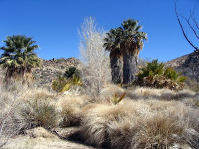
We finally arrive at the Cottonwood Springs Oasis.This was created by earthquake activity many moons ago,and at this time had no visible water,as I have seen it before.Probably too late in the season.And of course plenty of bird activity,but difficult to see as they fly in and out of the big grass skirts on the palms.


Below is a look inside.Its fenced off,so no entry.I bet on a hot summers day,that its 20 degrees cooler in there.


Nearby we found 2 granite bedrocks(below) that were used by the Cahuilla (Salton Sea Tribe)to grind up seeds etc.You can just make out the hole in the second rock also.The holes are almost a foot deep and as the sign suggested,must have taken a long time to grind down that deep.


We carried on further down the wash from the oasis and noticed the varied plant life changing as we walked along.As you can see fluffy grasses started to appear and a humming bird gave us a little display,flashing its red chin in the sunlight.(no pic)


This tree I thought was a standout,as it shimmered so white in the sunlight.


You may ask....Where are the Joshua trees?....Well,this park is in 2 distinctly different deserts.The low Sonoran/Colorado.....and the high Mojave desert.The Joshua is in the high desert and we will be travelling to that part of this National Park on Friday morning,as we pick out another campground near 29 Palms Ca. Which will be our last stop before heading toward home.


Wednesday, February 18, 2009

Welcome To Yucca-Ville

It was the start of of a nice warm day when I left the Salton around 8:30 and headed over to the dump station at the headquarters camp.I love it when I find a dump station with no line up and no sign of anyone being there recently.I could take my time and deal with an ever increasing problem of stiffness in the cable system of the valves.All went well with a nice background sound of the nesting cactus wrens and doves to serenade me as I feel the warm sun getting stronger.But all that would end.
I met up with Ron and Sue at Mecca,as they needed propane and a gas fill up.We headed out to the north east on a back road over toward the I-10 steadily climbing through the Painted Canyon area.This has always been an area where on past trips I saw a few boondockers,but nary a one this time.I did notice many big boulders strung across roadways in the area,but some spots where still open.Really a pretty boondocking spot.
I watched the temperature on my van's "heads-up"slowly start to drop from a rising 62(17c) at Mecca,to 51(12c) as we crossed the Interstate and headed into Joshua Tree N.P.We had another 1500ft to climb as I also watched the altitude on my Garmin.
The whole trip took just over an hour as we arrived at the Cottonwood Campground.It was about 1/3 full and very tight, small sites,half are pull offs along the roadway,and the other half are short back-ins.After a few circuits of the 2 campground loops,and yaking on the radio,we finally decided.I took a pull off because I don't plan on unhooking and R&S took a back-in so they could use their slide- out.No slide-outs allowed on the pull offs.
We got out of our rigs and were met with the reality that at 3100ft,its going to be cooler,and it was,49(10c)No warmth coming from the sun with a slight breeze.Oh well!As we head home in a week,we might as well start getting used to it as of now.

After setting up on blocks(many needed)Sue and I took her car and drove back to the Visitor Center to pay for 3 days.There is an honour system but we didn't know about the park entry fee and if a camping fee covered it.After standing in a line up filling out our envelopes,we reached the lady ranger at the counter.I handed her the envelope and asked about the entry fee and she says yup!Gotta pay that too,as she actually threw my envelope over her shoulder and said"don't need that!Just need your money!And proceeded to fill out a slip for us to put on the post.Never seen so many "hairy chested"lady rangers in my life.(It was actually all done with a smile.)

I wasted most of my day setting up the Internet and trying to change the Weather map and Google map on the blog.This is still very much a learning curve for me,being computer illiterate an all.
As all this was going on R&S were meeting our neighbor Mike (in pic above)from Olympia Wash.
He is going through the same situation as me,learning to cope with having a wife in a nursing home and still trying to enjoy travel while we can, before its our turn.


Well, the setting sun is shining on the distant hills and we are in for a colder night then what were used too.....methinks....This morning we plan on hiking over to the Palm Oasis,so will have more on that tomorrow.

OUR NEW LOCATION