Search This Blog

Friday, July 31, 2009

Whitehorse....And Still Hot

I got an earlier start out of Boya Lake yesterday,figuring to get in as much driving as possible while its still a little cooler.That last 50 miles of the Cassiar had some gravel patches so I slowed down for all of them just in case there were any real rough drop offs like the one I hit the first day out of Tunkwa......Well I slowed down for all but one.....This one was over a rise and not seen until the last second....and you guessed it.....A doosie...I had doors open in the trailer that have never opened before while under way.Anyway no damage found so far.
A quick top up of gas at the junction of the Alaska Highway(no more pre-pay...Hooray!)The Alaska highway was nicer than I expected as I rolled westward,more traffic of course,mostly r.v.The countryside was Rolly like the foothills of Alberta with an altitude around 2000 ft, and for awhile no mountain was in sight.I had forgotten that I was actually east of the great divide,which I crossed coming out of Dease Lake on Tuesday.After awhile you start to see the mountains looming in the distance and the highway takes a 42 mile dip back into B.C.It was while I was on this stretch that I made a rest stop and found this interesting bit of info below.This is Simpson Peak.
And here's a bit of an explanation on how it was formed.

Below is another stop.....These next 2 photo's have been done to death by other bloggers and in Yukon guide books,so I will add my perspective.Below is the rest area on the hill above the Village of Teslin.

And this is the Nisutlin Bay bridge,the longest water span on the Alaska highway,1917ft/584 meters and boy did the metal grate decking ever ever throw me around,I was glad no one was coming the other way.
It was just west of here that I had planned on making my stop for the day,so I started checking out a few government campgrounds,but found them hot and dusty with a look of being well used and if I wanted to set up my satellite dishes,there could be a problem with all the tree's.The only good site for that in the first campground I checked, was just taken by some clown that earlier had been nipping at my heels,tailgating me on the highway.....I had gotten tired of him and let him pass...so he took the only spot I would have taken.
It was getting hotter and all the campgrounds were not to my liking,so I figured,instead of making this a 2 day trip to Whitehorse,I'll make it a one and go into an r.v.park and enjoy my first full hookup since setting off on this little trek a month ago.I was able to make good time on this highway and around 3pm,arrived at the Pioneer R.V. Park a few miles east of city centre....The city limits extend out into the boonies.
And here I am in a dusty,dirty,parking lot style,$28. a day spot in 33/90 degree heat with all the big boys....BUT...Was that air conditioning ever nice!I had had enough heat for awhile and enough bugs for awhile,because in those nice lakeside parks,the bugs would sometimes drive you inside....then the heat would drive you back out to the awaiting bugs....just a vicious circle.So I'll spend a few days enjoying A/C and no bugs.


For those of you who travel with a Star-Choice T.V. system,I found quite a large drop in signal strength here,maybe its my location but I couldn't muster much more than 28 with most stations breaking up,so in the evening when the sun wasn't beating on me,I tried tweaking it and finally got it to 37 and no breakup,but boy! it was soooo touchy.You'll note that my neighbor from Oregon has the datastorm internet dish on his roof as does his neighbor,in fact when I set up mine,I found about 5 other signals,half of them unsecured,so really I guess I didn't have to set mine up.They will probably leave before me anyway,so just as well.
So....today we will see what Whitehorse has to offer.


Thursday, July 30, 2009

One Hour "South of 60" And Still No Heat Relief.

Another 8a.m. take off on Tuesday, to start the 2nd half of the Cassiar,actually its called the Stewart/Cassiar Highway I believe.As I left Kinaskan Park and followed the lake shore northward,the climb started into the high country.You could see the mountains had less of a snow patch as I travelled away from the coastal range.It was so nice just to drive a quiet highway and take in all fantastic scenery.Speaking of highway...It was starting to deteriorate a bit...not as wide....not as smooth..choppy,dippy...sort of like the Mexican roads without the potholes.The top photo is a view of the Stikine Valley and river,another big one that I learned about in school and now am finally getting to see,like the Skeena and Bulkley a few days before.The shot below is Knat lake just before the town of Dease Lake.I had to stop and walk back a get a shot of this vista.The picture doesn't do it justice.This is moose country......but no meese's were found.
Ok you experts....whats this flower on the side of the road?There were many at this stop,growing at the edge of the pavement.
One thing I missed was having a good look at Mount Edziza,a 2728 meter extinct volcano,that's just over 9000 ft.I caught a glimpse of it by accident in my side mirror and was hoping for a pull off that afforded a good look but never saw the mountain again.It was a beautiful sight all covered in snow glistening in the sunlight.

A gas top up at Dease Lake was next...These places are where you find out that the "hoard" is still out there,even though you are travelling a lonely highway in the middle of nowhere...thinking that you are all alone.....when you want gas....so does everyone else at the same time.This little Indian town with just one gas bar/grocery store was the hub of activity as locals and the travelling public,all seem to converge at the same time.5 minutes later and I would have been stuck behind a small caravan of r.v's waiting at the pumps.After Dease Lake ,came the road construction,first a wait,then mud,lots of mud,then the dusty stretches,lots of dust......and coupled with the rising temperature,made for the beginning of an uncomfortable next couple of hours,but alas.....around 1pm,I arrived at my dusty little oasis of a Provincial Park Campground....and yes some open sites along the lake.....what a beautiful turquoise colored lake!Here's a nice site just waiting for someone..below.


I took the first one I came to...I wasn't going to take any chances,so here I am finally set-up,even with my own little swimming beach.Just as I finished backing in,along came another rig that parked next door...They where a nice couple from Tampa Bay Florida in a Class-C...so after setting up we got together for an extended "happy hour"and exchanged info as they were heading south,so we all learned valuable info on what to expect in our travels.

I decided with all this heat that I need to take another day's rest and this was a good spot to do it.I sorta like the travel for 2 days/stop for 1 idea,its worked well in the past. So below is Willy, thinking.......should I go for a swim?This is a northern lake....The ice probably just came off a couple of months ago.

HEY! This is not so bad....not cold at all.

AHHHHH! Relief from the heat....and crystal clear water too.....

That brings me to this morning....just coming up on 5a.m. as I write this and the trailer hasn't cooled off much and everything that opens....is open....So in a couple of hours I hit the road again and after an hours drive, will be "North Of 60"and into the Yukon.......how far do I have to go to get cooler temps you ask?.....well Whitehorse topped 30 yesterday,that's getting close to 90f and we were the same here....Maybe the north pole.......stay tuned..................Hey all you people back home reading this....I know its hotter where you are, so stop complaining Willy.Yesterday Chilliwack broke a record at just under 36 with a humid-ex of 42.....shades of Ontario in other years....not this year tho....I feel for them.......a little.....(insert smile :)


Tuesday, July 28, 2009

Another 250 Kilometers North And Another Nice Park

As the sign says at the junction of 37 and 37A...North to Alaska....So on another fine morning, I set off to travel another 200+k's.I find the distance between these parks are just a nice drive for an old guy,it usually gets me into the next park around noon.
I hadn't gone far when I came upon this guy grazing flowers along the roadside,so I quietly coasted to a stop and took an "out the window"shot as he was only at the edge of the pavement.I tried to strike up a conversation with him/her but he/she just gave me the claw and sauntered off.Couldn't have cared less is I was there or not....jeeeze! even bears don't like me....I'm getting an inferiority complex.Odd thing on this trip I've seen lots of bear activity, as twice in the past week I've seen Mama and 2 small cubs crossing the road,usually early just after setting out.

The drive is so relaxing on this lonely highway,only one car passed me going the same way in 3 hours and no more than 50 heading south,half of them r.v.'s.Below is one of the very few lonely outposts along this stretch,Its called Bell 2 Lodge.Along with the main building which houses coffee shop and gas/diesel pumps,there are also 20 guest chalets and a campground.This is one of Canada's premier heli-skiing operations.A resident chopper was just taking off as I arrived,but I doubt it was for skiing this time of year unless there's a glacier around.


Its a beautiful drive with so many snow patched mountain vistas and fast running gray,glacial streams and rivers,and as I was nearing my destination for the day,I noticed how the vegetation was slowly changing from the more coastal temperate to the harsher northern boreal, with white and black spruce,also trembling aspens and a few lodge pole pines.Below is one of the many nice rest stop pull-off's.This is the "Bob Quinn Lake Airport."


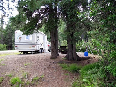
And finally just before noon and just after passing the halfway point on the Cassiar Highway,I arrived at Kinaskan Lake Provincial park,50 sites along the lakeshore,only about 10 occupied when I arrived on this sunny 70's day.The set up was a little frustrating because of an abundance of small sticky house flies that like to crawl all over your face when your hands are busy.(Sorta reminded me of the Salton Sea in November)


Its a good sized lake and the fishing is a little different as we start getting into the whitefish and char country along with lake trout.There was a lot of float plane activity during the afternoon,going to a dock not far from here.


And a final shot of my campsite taken with just my heels in the water.Today another 4 hours should get me to Boya lake Park just south of the Yukon border.I'm already noticing the longer days,I usually bed down just after 9 and the sun is still high in the sky.I woke up at 1am today to do what old guys have to do,and noticed that the northwestern sky still had a bright glow.


Monday, July 27, 2009

Great Weather....Beautiful Country...Ah! Life In Northern B.C.

This is Meziadin Lake and Provincial Park Campground,my first stop on my northward trek on the Stewart/Cassiar highway, which eventually hooks up with the Alaska Highway just west of Watson Lake Yukon.
This is a campsite I could have had...It was the only open one along the lake front when I arrived at noon on Saturday.The first few hours drive north gave me the feeling that I was leaving civilization behind as the road got quieter.Just a smattering of R.V.'s heading south from their trip to Alaska(mostly Americans)"Merkins"as I fondly call them.
I was surprised to find the campground more than half full when I arrived at noon....This is the middle of nowhere you know....None of the Provincial parks on busier highway 16 were like this.Then I realized that between here and the Yukon border are only 2 more of these parks so people get in early as there is a fair amount of R.V. travel on this road.............Now we jump to..................................Yesterday,Sunday....my day trip to Stewart/Hyder......Below is one of the many small glaciers along this 50K stretch of road.....what a beautiful day..warm.....low 80's....look at that blue sky.....I'm so fortunate to see this area in good weather as they don't get a lot of that here.

One downer on this little side trip was more "seal coating" of the highway,a dusty process.They guide you by pilot car.I had a 15 minute wait so I talked to the nice flag lady and found that the Bear Glacier(the big one on this road)was in the middle of the piloted stretch of road......Hey! I want to stop and take photo's I exclaimed as I jumped up and down...not be piloted through in a cloud of dust....Can I leave the group?....sure she says but you are on your own.....ok...good.(I didn't really jump up and down.....I was just playing Drama Queen........or drama guy....or something.Here is the first shot from a distance.


Here is a close up....look at that blue color.


And a medium distance shot below.


I carried on toward the town of Stewart alone,catching up with the others at the end of the pilot run.....below is the downtown of this town of a little less than 1000 people.It is situated at the head of the Portland Canal,a salt water fjord that is 90mi/145k's long.It is a natural boundary between Canada and the Alaskan panhandle.


Here is a shot of the mist trying to surround the pier.


A view of the Canal looking back toward Stewart.


Entering Hyder Alaska....you just drive in....no U.S. customs....but you have the Canadian customs when you come back out....asking all the usual questions......what did you buy etc.Jeeeze....I never even though of buying anything.


I drove through this spread out town of around 100 people and carried on for a couple of miles until I reached this place below.


This is where everyone comes to view the grizzlies eating the spawning salmon from the safety of the viewing stand.You can see it goes quite a distance.The small parking lot was full so I found a 2nd parking lot and went back to the entrance only to find that you had to pay to enter.......I forgot I was back in the U.S...So I gave him my 3 Toonies and entered........Not a good time as the last bear sighting was earlier that morning when a grizzly and her young one were down eating fish.I looked around amongst the people,many with camera's and huge scopes waiting for something to happen and asked......anything happening?Well we got spawning salmon and we saw a bald eagle a while ago a guy says......geeze,I thought....I paid six bucks to see what I can see in my back yard at home for free.Oh well it was a nice experience on a nice day and it was my first visit to Alaska.


Coming back I went through the usual Border questions(no line-up though)and headed back to camp.Below is a waterfall you can see all the way to the top of the mountain.I only took a shot of the lower part to capture the large snowbank that it drops into...................A side note......Anyone know how I can stop the spacing between pictures from spreading out more and more as I go down the page?This is driving me crazy!


A final shot looking back toward Stewart as I wait for the pilot car.Look at that gorgeous blue sky.


Saturday, July 25, 2009

Kitimat And Terrace...35 Miles Apart And Totally Different

Yesterday was my Kitimat day,just a few miles down the road from the campsite here at Lakelse lake....10 minutes in and some regrets..road construction...pilot car...6 miles of pure fine dust....choking dust, because I was following 2 -18 wheelers and a loaded logging truck....It was like driving in thick fog....at one point I almost ran into the back of the 18 wheeler as you couldn't see beyond the hood of the truck.Nuff said.
I drove all the way to the end of highway 37 where the big Alcan Aluminum Smelter is located at the head of Douglas Channel....It is huge,I travelled over 1.5 miles,looking at continuous smelter operation.The pic above is just the end of it.Below is the large Eurocan Pulp Mill just up the road.
This is a Planned company town built in the 50's and the town proper is further in, away from these monsters.The large residential area is centred by the business area which is really just like a large shopping mall.The pic below is one side of it.It has many shops,restaurants and 2 gas stations,all across the road from the start of the residential area.I think parking is not a problem,many of the 9000 people live within walking distance anyway.The industrial services like building supply and service shops are midway between the town and the smelter,also in a large separate cluster.....OOOPS!I just spilled coffee all over myself and my bed.....geeze...and I just did the laundry 2 days ago.....time out.

I got lost in the vast residential area and had to ask Miss Garmin to extricate me....she came through with flying colors and got me up above to a park on the highway which overlooks everything.You can see Douglas Channel in the distance with the town below in the trees.


Below is a closer look....Just think,that saltwater channel goes about 55 miles before it reaches more open water at Gil island,which I believe is where the Queen of the North...The Rupert/Port Hardy Ferry sank,hitting Gil Island a few years ago.


Here is a shot(below) of the little park where I took the previous pictures.


And at the city limits is this sign...Over the next few days I may follow this route north as the extreme heat is coming this way,driving me further north.


Thursday....Laundry/haircut/shopping day
In Terrace.


This is a nice little city of around 11000,here are a few downtown scenes.


Below reminds me of Wellington St. in Chilliwack.Same set up Exactly.


So this is travel day as I backtrack a bit and head further north up highway 37,the "Cassiar."I don't know how far I will go but my original plan a couple of weeks ago was to go at least as far as Stewart/Hyder Alaska,which will be in my day trip range by tonight,when I hopefully stop at Meziadin Lake PP.


Friday, July 24, 2009

No Rain In Prince Rupert This Day....And Just For Me.

In my last blog post I said I was going to Kitimat that day....well....I lied...I realized that if I wanted to see Prince Rupert on a Sunny day,I better strike whilst the iron is hot.So trust me....Kitimat is back on the front burner for today...my last day in this area.The above photo is of the Skeena river about 75 Kilometers upstream from Rupert......Man this is a big impressive river.....literally hundreds of fisherman were lining the banks as I came out of Terrace....and this went on for many miles.....must be a big salmon run .
Prince Rupert is on an island,(Kaien Island) and when I crossed the Galloway Rapids bridge and on to the Island,I thought I was just crossing a river at the point where it enters a lake,as I was still out in the wilderness,with no city in sight.But found that the lake was really Wainwright Basin,and the salt chuck...then I continued to drive through small lake country,one with a Provincial Park campground,then all of a sudden a sign proclaiming that I was entering Prince Rupert......Yup...A McDonald's..Civilization.

I drove straight up the main street,still highway 16,and my first impression was,wow...this place is bigger than I thought....I drove until the road ended at the ferry dock..You can see a B.C. ferry in the second photo.Don't know which one.
This is the fisherman's docking area next door to the B.C. and Alaska ferry dock.


Parking was at a premium so little time was spent looking around and taking photo's,so I headed back up town and parked,deciding to get out and walk around with camera,feeling like and looking like some jerkwater tourist.Below is the front of City Hall.


And a street scene along the centre of the 3 main streets that run the length of the downtown.Actually I'm doing justice with these pic's because most of the downtown when you really get and and look.....is pretty shabby,with many store fronts empty, in fact I even felt a little uncomfortable walking some of the streets when hearing footsteps behind me,as the downtown outside of a couple of blocks was pretty quiet.
How many people do you see in the pic below?


Well it was lunch time,so I dropped into Timmy"s for lunch and tried their chicken wraps...It, like all Tim Hortons was fairly busy...With all the rain this place gets,not too many tanned faces, as I looked around while waiting for my order.....just the natives....not a racial slur,just had to inject a little humor....Its my blog I can say what I want.
Time to gas up at the Chevron(my preference)Funny they are only in B.C. as far as Canada is concerned,unless times have changed since my last for- aye out onto the prairies.Heading back out of town and off the island,I went into Port Edward for a look see and took this photo of a large cannery,only about 1/3 of it shows in the photo.


And finally a final shot(below) of the Skeena river about 50 k's upstream,it gets to be more than 5 K's across in these lower areas and I noticed the tidal waters start showing up about 75 K's upstream.Its a beautiful drive all the way from Terrace,over 200K's. Reminds me a bit of the north side of the Fraser from Hope to Agassiz,only the mountains are prettier with quite a bit of snow even down to the road in patches and the altitude over this stretch is only 150 meters.On a sunny day this trip is a must.


I didn't make it all the way back to Terrace before,with eye's drooping,turned into one of the many pullouts and climbed into the passenger seat....reclined it...and....zzzzzzzzzzzz.Got back to camp around 5pm,a long day,but worth it.